We were called to a site near the cliffs of the Saint Lawrence River where a new residential complex was planned. The developer had concerns about variable bedrock depth and potential clay lenses that could compromise shallow footings. Instead of drilling blindly, we ran a grid of Vertical Electrical Soundings to image the subsurface resistivity contrasts before any excavator arrived. In Levis, where the geology transitions from the shale and sandstone of the Appalachian foothills to deep marine clay deposits, a seismic refraction survey can complement the resistivity data to resolve velocity boundaries at depth. The VES profile revealed a steeply dipping bedrock surface at 6 meters on the east end, shallowing to just 2 meters on the west—information that directly shaped the foundation design and saved the client from costly over-excavation.
A 4-electrode sounding can map bedrock topography and clay thickness across a 100-meter transect in half a day, with zero soil disturbance.
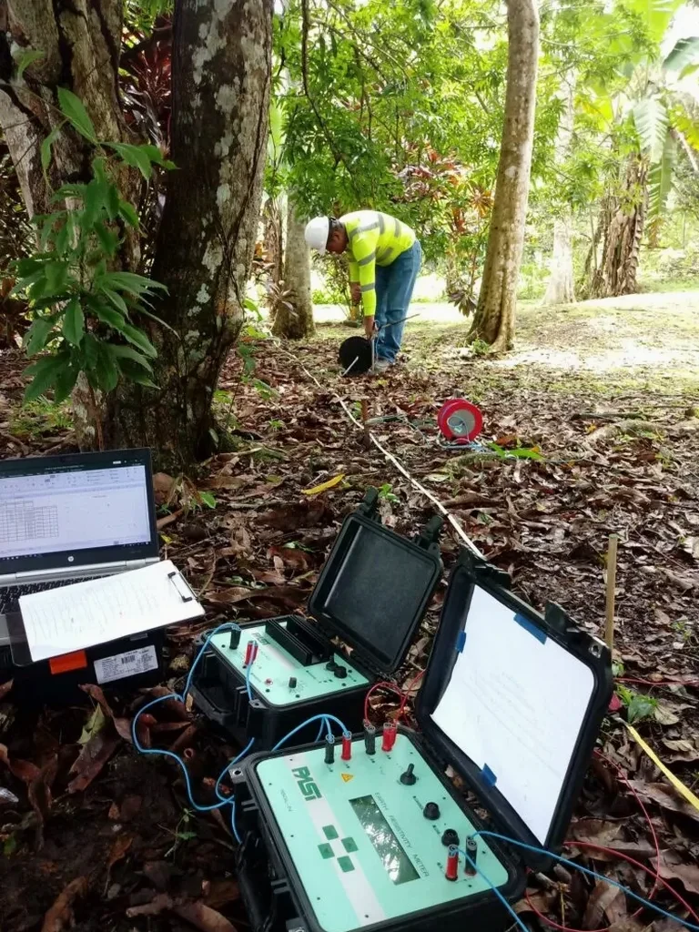
Process and scope
The resistivity method in Levis works by injecting a controlled DC current through steel electrodes and measuring the resulting potential difference. We typically deploy a Wenner or Schlumberger array, with electrode spacings ranging from 2 meters for high-resolution near-surface mapping up to 50 meters or more for deep soundings. The Quaternary stratigraphy here—glacial till overlying fractured Appalachian bedrock—produces a distinct resistivity signature: till and clay read between 10 and 50 ohm-m, while competent sandstone or shale bedrock climbs above 200 ohm-m. Saturated zones drop the apparent resistivity sharply, which helps us delineate the water table position without installing piezometers at every location. Data processing uses least-squares inversion software that iteratively fits a layered earth model to the field curve, yielding true resistivity and layer thicknesses with a typical RMS error below 5%. We cross-check VES interpretations against available borehole logs and, when ambiguity persists at depth, we recommend targeted drilling at anomaly locations.
Local ground factors
The Quebec Construction Code references CAN/CSA-A23.3 and the National Building Code of Canada, both of which require adequate subsurface investigation before design. In Levis, the risk is compounded by the Champlain Sea clay deposits that blanket much of the lower terraces—these sensitive clays can lose strength dramatically when disturbed or saturated. We have seen projects where undetected clay pockets led to differential settlement within the first two years of service. Electrical resistivity imaging helps us map these low-resistivity zones laterally and vertically, flagging areas where the clay thickness exceeds what a standard borehole might suggest. For structures near the river bluffs, we also assess the potential for seepage paths that could destabilize slopes, a concern that grows heavier during spring thaw when the water table rises sharply.
Frequently asked questions
What depth can a VES survey reach in the Levis area?
The depth of investigation depends on the maximum current electrode spacing (AB/2) and the subsurface resistivity. With a Schlumberger array and AB/2 of 150 meters, we can typically resolve layer boundaries down to 50–60 meters in the glacial and sedimentary deposits common around Levis. In high-resistivity bedrock, the effective depth increases; in saturated clay, it decreases somewhat because the current tends to stay in the conductive layer. We always design the maximum spread based on the expected target depth from preliminary geological data.
How much does an electrical resistivity survey cost in Levis?
For a single Vertical Electrical Sounding with full interpretation and a written report, costs range from CA$910 to CA$1,330 depending on the maximum AB/2 and site accessibility. A 2D ERT profile line of 200 meters typically falls in the same price bracket per line. Projects requiring multiple soundings or profiles over several days are quoted on a package basis, which reduces the unit cost per station. All quotes include mobilization within the greater Levis area, data processing, and a stamped engineering report.
Can electrical resistivity distinguish between glacial till and Champlain Sea clay?
Yes, quite distinctly. The Champlain Sea clays in the Levis region are saline and highly conductive, with typical resistivity values between 5 and 30 ohm-m. Glacial till, which contains a mix of silt, sand, and gravel clasts, generally reads between 40 and 100 ohm-m depending on compaction and moisture content. This contrast is sharp enough that the inversion algorithm reliably places the layer boundary within a few decimeters of its true position. We validate this interpretation against Atterberg limits and grain size data from borehole samples whenever they are available.