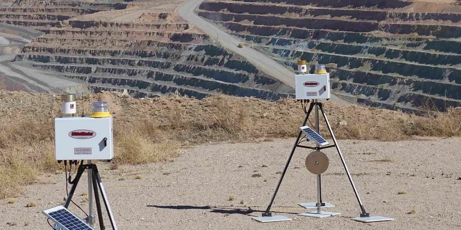
The most expensive mistake on a Levis deep excavation isn't the shoring collapse itself — it's the six months of lawyer fees arguing about who missed the lateral movement on Tuesday afternoon. We've pulled data logs from failed projects across the Rive-Sud, and the pattern is always the same: someone installed the inclinometer casing but checked readings once a week instead of daily. At 46.80°N in sensitive Champlain Sea clay, a 6-meter cut can creep 15 mm overnight after a rainstorm without visible cracking at the surface. That lag between visual inspection and actual displacement is where the liability lives. Our deep excavation monitoring instrumentation programs are built around NBCC 2015 Section 4.2.4 requirements and the reality that Levis contractors need actionable data — not a PDF report arriving three days after the movement already happened. We combine automated total stations with wireless tiltmeters to deliver threshold alerts before the morning toolbox talk.
In Champlain Sea clay, a 6-meter cut can creep 15 mm overnight after rain — without a single crack visible at ground surface. If you're not reading inclinometers daily, you're gambling on luck.
Local ground factors
Levis sits at just 88 meters above sea level along the escarpment, but the real risk factor is what lies underneath: the Champlain Sea clay unit that deposited here roughly 10,000 years ago when the post-glacial sea covered the St. Lawrence lowlands. This clay has a liquidity index frequently above 1.2 in the upper 8 meters, meaning it behaves closer to a viscous fluid than a solid when disturbed. Excavations that bottom out in this material can experience basal heave with almost no warning — we've documented cases where the excavation floor rose 40 cm in under three hours after a heavy rainfall event near the Saint-Romuald sector. The sensitivity of this clay, often exceeding 30, means vibration from compaction equipment or even passing CN rail traffic on the west side can trigger remolding and strength loss at the toe of a cut. Monitoring programs here have to be redundant by design: if a single inclinometer casing gets sheared off by unexpected movement, the piezometer array and the total station prisms still give you a complete picture of what's happening underground.
Frequently asked questions
What is the cost range for excavation monitoring on a typical Levis commercial lot?
For a standard 6- to 8-meter deep urban excavation with inclinometers, piezometers, and automated total station coverage over a 4-month construction window, budget between CA$1,010 and CA$3,160 per month depending on sensor density and reporting frequency. The spread covers a basic 3-inclinometer setup up to a fully redundant 8-sensor array with web dashboard access.
Do Levis municipal permits require third-party monitoring or can the contractor self-perform?
The Ville de Lévis typically requires independent third-party monitoring when the excavation depth exceeds 4.5 meters or when the cut falls within a zone of influence of adjacent buildings per NBCC 2015. Contractor self-performed readings are accepted for shallow cuts under 3 meters, but the engineer of record must still certify the data.
How do you handle monitoring during the freeze-thaw season from December to March?
We install thermistor strings alongside inclinometer casings and calibrate displacement readings against temperature profiles. The top 1.5 meters of clay in Levis experiences cyclic heave of 5–10 mm during freeze-thaw — our automated filtering algorithms separate this seasonal signal from genuine excavation-induced movement so you don't get false threshold alarms in January.
What frequency of readings is required during active excavation in Champlain Sea clay?
For Class 3 excavations in sensitive clay, we recommend automated readings at maximum 4-hour intervals during active digging, with manual verification once per day. If pore pressure changes exceed 15 kPa in 24 hours or lateral displacement rates exceed 2 mm/day, we escalate to continuous monitoring with real-time alerts until the movement stabilizes.
Can the monitoring data be integrated into our existing project management or BIM platform?
Yes. Our data loggers output in CSV, SQL, and API formats compatible with Procore, Autodesk BIM 360, and custom dashboards. We set up automated daily reports pushed to your project engineer and the municipal inspector simultaneously — no proprietary software lock-in, no manual data entry delays.